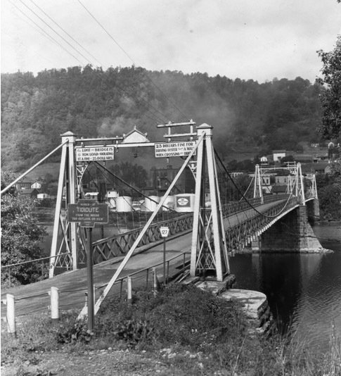
The earliest known photograph of a Keystone Marker. Location is Tidioute Bridge. Courtesy of PHMC
Created by PennDOT’s predecessor, the Pennsylvania Department of Highways, just after the First World War, the markers were products of the height of the “Good Roads” movement then sweeping the nation. Founded in 1903, the Pennsylvania Department of Highways was one of the earliest of such departments of any state in the nation and its markers were literally signs of Pennsylvania pride.
One of the earliest turnpikes in the nation between Philadelphia and Lancaster was begun in 1793, and proved the financial advantages of a well-maintained highway. The first federally-funded interstate highway, the “National Road”, (today’s U.S. Route 40) traverses south-western Pennsylvania. It ‘was constructed through the Commonwealth in 1811. In 1913, the Lincoln Highway Association was formed to build one of the first modern transcontinental roads, and its route would cross the length of Pennsylvania. The Pennsylvania Turnpike, opened October 1, 1940, was considered to be the embodiment of the future of modern travel and set design precedents copied around the world.
Many publications showcased the Keystone Markers as Pennsylvania’s tell-tale; Indeed, it was the Keystone Marker program that cemented the keystone shape’s association with the Commonwealth. This 1930 map from the Pennsylvania Department of Highways features the Lincoln Highway and the William Penn Highway and shows the pride the state once took in its system. Notice the keystone markers used in the legend at the lower left. (Map courtesy of Matt Hamel). This 1923 atlas image from the Best Roads of the United States atlas also features keystone markers in its legend (photo courtesy of Christian Busch).
The Highways Department published a small booklet in 1927 entitled: PENNSYLVNIA HIGHWAYS, Facts Motorists Should Know. An article in this booklet by then Secretary of Highways James Lyall Stuart stated:“The state has been noted for its historical signs at all points of interest, signs at the entrances to boroughs and cities, and its standard warning and direction signs. . . . . . . . The wording is brief and to the point, and the uniform keystone design used throughout makes it easy to find the sign.”
The Keystone Markers are tangible reminders of this great heritage and serve as inspiration for the future.
A History of the Keystone Markers by Jack Graham, Keystone Marker Trust
The historic “keystone markers” of Pennsylvania, so called because of their iconic keystone-shape associated with Pennsylvania, are made of cast iron. When new they were painted dark blue; the edge of the signs and the lettering were bright gold/yellow. They were mounted on a decorative fluted cast iron post that was also painted the same dark blue. These, of course, are the colors associated with Pennsylvania. Unlike modern town name signs which only give the name, these cast markers also gave the following information: distance to the next town, some bit of information about the derivation of the name, and the year in which the town was founded.
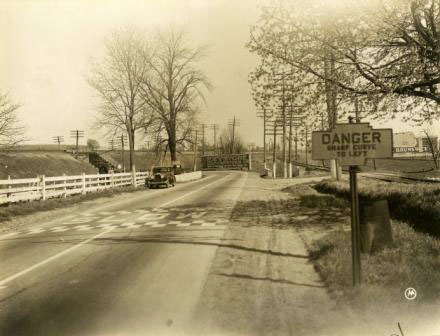
A typical “Danger” Marker.
These markers were a project of, and were produced for and installed by the state Department of Highways, predecessor of today’s Department of Transportation (PennDOT). The Department of Highways Biennial Report for the 1926 to 1928 period, viewed at the State Archives in Harrisburg, states: “The Department also makes a practice of marking the limits of boroughs with cast iron signs on which are a few facts as to the date the community was founded and the derivation of its name.” No earlier reference to these markers has yet been found. Highway Department documents as late as 1943 continue to make reference to these “historical” signs. After that no such references are found, so it is logical to conclude that the program was discontinued around that time. Thus the “newest” of these markers are at least 80 years old.
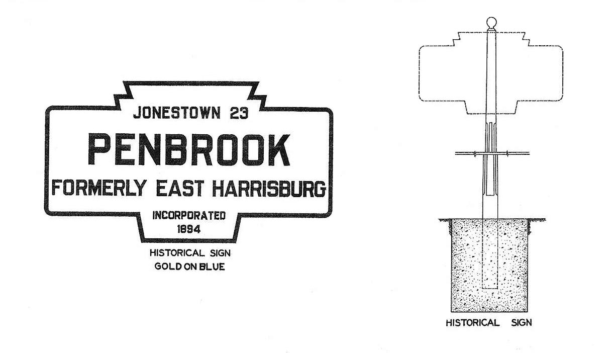
Pennsylvania has an extensive program of “Historical Markers,” also blue and gold in color, that give much information about persons, places, buildings, and events in Commonwealth history. These signs are a project of, and are produced, installed, and maintained by, the Pennsylvania Historical and Musuem Commission (PHMC). A complete index to these markers can be viewed at pahistoricalmarkers.com. Stories related to the markers can be accessed via explorepahistory.com, a collaboration between PHMC and public television station WITF. Perhaps because of their color, one could assume that the remaining Keystone Markers were also put up by the PHMC, and thus that a good index to them is existent. Unfortunately this is not the case. Thus far at least, no record of all the Keystone Markers has been found in Highway Department files at the State Archives. It is clear that varieties of the keystone marker and pole were used for a host of purposes, including speed limit signs, no parking signs, directional signs, etc. A 1938 Highway Department manual notes that keystone shaped signs were used to mark the “Location” of such features as “cities and towns, rivers and streams, mountains, and historical sites.” Their most common and lasting usage has been to denote towns and water courses.
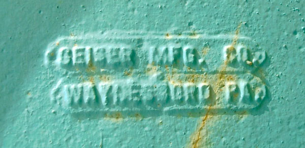
Some of the markers show the name of the manufacturer in small letters on the reverse side. Many of them show no such names, or the lettering has become obliterated over time. The two companies that are known to have made these signs are: (1) Carlisle Foundry of Carlisle, Pennsylvania; (2) Geiser Manufacturing Co. of Waynesboro, Pennsylvania. Both firms are long out of business. Whether the unmarked signs were made by these same companies, or if there were other makers, is unknown. No other foundries have as yet been connected with the production of these markers. Photographs of the makers’ marks are below.

Multiple Unique Markers for Each Town
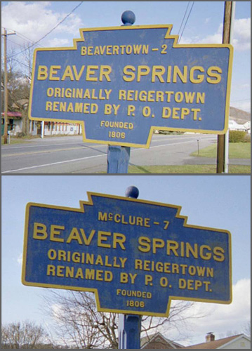
Two markers at Beaver Springs. The top line differs depending on your direction of travel.
In towns where the markers were installed, at least two were put up, one on each end of town along the major “state road.” Usually this was a numbered “PA” route (PA 45 for example), or a numbered “U.S.” route (U.S. 322 for example). If a town was at the intersection of two such roadways, there were four signs installed, two on each road. All of the information on the several markers at one town was the same, except for the name of and distance to the “next” town. This differed depending on which direction the viewer was going. The photos to the left show the two markers at Beaver Springs, (Snyder County), Pennsylvania. Note that the top line differs on each as the “next” town is different depending on your direction of travel.
Some of the markers omit the top line about a “next” town, but this is the exception. A few omit the “Founded” date at the bottom, or say “Settled” instead. In a few instances it is evident that the top line letters were removed for some reason. This sometimes happened where new “limited access” highways cut off old roads, so that the old joke “you can’t get there from here” became true, or when the markers were relocated from their original placement.
Where the markers remain, and particularly if they are in good condition, it is because the community, or more likely some enterprising person in the community, has stepped forward to repair or repaint them over time. Being of cast iron, they are very brittle and subject to breakage. A surprising number show evidence of being repaired, some poorly some well. Far too many, however, stand neglected at the side of the road, as towns wait for someone else to do it. Suprisingly too, many local officials don’t even know of a still surviving marker.
Some Notes on Marker Text (see also What the Markers Denote)
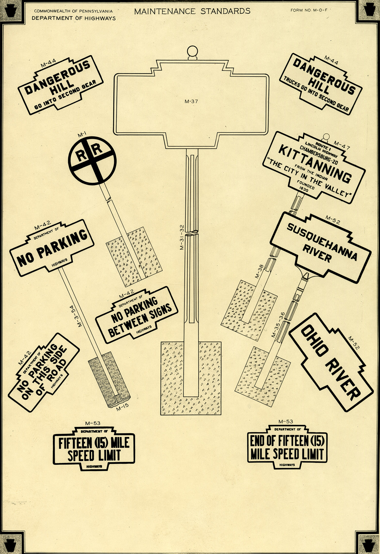
This maintenance standards drawing produced by the Department of Highways shows the many uses of Keystone Markers.
The text of the signs, specifically the town name information, was apparently the product of a committee on which Pennsylvania Folklorists Henry Shoemaker and Albert Cook Myers were heavily involved. Shoemaker and Cook were the Chairman and Secretary of the PA Historical Commission (predecessor agency to today’s PHMC.) Shoemaker stated in the Historical Commission report to the Governor for 1923-27 that he and Myers had been “actively engaged in securing historical accuracy for the numerous metal marker signs for the towns and physical features of the Commonwealth erected by the Department of Highways.”
The several items of information on each sign include: the name of the next town down the road and the mileage to it; the name of the town being entered; some bit of information regarding why the town was so named; and the year the town was founded. In some cases the information about the founding date is not included, but this too is the exception rather than the norm. Many of the signs reference a previous town name, rather than a reason for the current name. In many cases why it was renamed is mentioned, but usually not; lack of space perhaps, or maybe no one remembered. It was not uncommon for many towns across the Commonwealth to have been given the same name, but with the coming of our modernized postal system, this had to be changed, and towns were renamed. For example, a town named Centerville can be found in eight different Pennsylvania counties. Only the one in Washington County was large enough to merit a post office. A town had to have been large enough to warrant a post office to be considered to receive a marker. A large number of the signs reveal that the town was named for a “pioneer settler” or other early inhabitant of the area. Clearly if you want a good chance of having a town named after you, start a new one of your own. Daniel Herr founded a Lancaster County town in 1877, but he chose to name it Refton, so the above doesn’t always hold true.
A drawing shows the “historical” marker, from the 1943 Manual of Regulations for Official Traffic Signs and Signals.”
Some of the signs give us clues as to the national origin of early settlers: New Florence (Westmoreland County) was named for a town in Italy – chances are the first settlers were of Italian ancestry. “Named for an early Welsh settler” is a pretty good clue the early folks in Jenkintown (Montgomery County) were from Wales. New Germantown (Perry County), was named for “old” Germantown, near Philadelphia, and was settled by folks of German heritage as they moved west.
The village of Airville, in York County, was named for the “pure air in the neighborhood.” I found it amusing that the remaining sign here is in the yard of a large dairy farm, and on the day I photographed it the distinctive odor of cows was almost overpowering. Since then some local volunteer has repainted it nicely.
Although most of the signs note a date the town was supposedly founded, I have a suspicion that in many cases the actual dates of first settlement are much earlier. The sign for the Lancaster County town of Lexington states it was founded in 1805, and that an earlier name was changed to commemorate the Revolutionary War battle of Lexington. As this happened thirty years before, patriotic fervor was still strong. The date is most likely the renaming date. The Ardmore sign in Montgomery County gives a founding date of 1873, the year it was renamed, having formerly been called Athensville since its original settlement. Some of the signs note a date the town was “incorporated” as opposed to “founded.“ This usually happened many years after the town’s founding. Some note the date the town was “settled.“
In some instances the date the town was “founded” according to the sign raises other questions. The sign at Washington (Washington County) for instance indicates it was founded in 1768 and named for “General” George Washington. George Washington was a retired Colonel of the Virginia Militia in 1768. He was not a General until 1775. The sign at the Franklin County town of Waynesboro gives a 1749 founding date and states it is named for General Anthony Wayne. This was long before the Revolutionary War officer was a General. Perhaps both towns had earlier names?
In general, the dates shown for different towns in the same counties give a good indication of when pioneer settlement began – the 1730s and 1740s for towns in Lancaster County for example; the 1770s for Perry County just west of the Susquehanna. Some towns appear to have been founded very late in counties settled much earlier. The sign for Ambler in Montgomery County for example says it was founded in 1857. Montgomery County, which borders Philadelphia is one of the earliest settled parts of the state. But Ambler is along the main line of the old Pennsylvania Railroad, which was coming of age in the 1850s, so maybe that’s the explanation. Delaware County, which also borders Philadelphia, had settlements in the late 1600s. It was part of Chester County back then, one of the three original counties created by William Penn. Delaware County was split off from Chester as the population grew and edged westward, and a new county seat was determined. So the fact that the sign for Media says is was founded in 1849 is correct, as it was a brand new town in an area that had already been settled for over a century and a half.
In at least one instance the information on signs at the same town differs slightly from sign to sign. If you approach the Lebanon County community of Jonestown from the north on a legislative route, you are informed that the town was named for William Jones, a pioneer Welsh settler. If you come into town from the east or west on what was once U.S. Route 22 (a new 22 and a newer yet Interstate 78 now bypass town) you are told that the it was formerly named Williamsburg, and was renamed for “Wm. Jones.” Space apparently did not allow to note he was a pioneer Welshman.
In spite of the efforts of Shoemaker, Myers, and others for accuracy, sometimes there were disagreements over the information on the markers, or it was just plain incorrect. The Beaver County town of “Frankfort Springs”, has a marker that says “Frankford Springs.” The sign at the Montgomery County hamlet of Tylersport, now tragically long gone, stated the place was named for President “James” Tyler. President Tyler’s first name was John. According to the sign, the Northumberland County town of Paxinos was named for a “Swanee” Indian chief. Paul Wallace’s 1964 book, Indians In Pennsylvania, gives a more accurate account, noting a Shawnee chief named Paxinosa in this area about the time of the French and Indian War. Sometimes conflicting versions of history exist. The sign at the Perry County town of Duncannon states it was “renamed” Duncannon for the Duncan family of early settlers. However local historian Samuel Sheller quotes a 1905 Government Printing Office publication which states the town was named for Duncannon, County Wexford, Ireland.
The original signs at the Crawford County town of Titusville noted a 1798 founding date. In 1934, the local Daughters of the American Revolution (DAR) chapter petitioned the Highways Department Secretary to replace the town name signs with ones showing a founding date of 1796. They also wanted the words “Home of the Drake Well, Birthplace of the Oil Industry” to be added. Although no marker remains there today, the one documented in the 1970s had those changes – the state actually listened and responded.
In perhaps the most glaring example of an error, the markers erected at the York County town of Mt. Wolf stated that it had been named for George Wolf, a colonial-era Pennsylvania Governor. The townfolk agreed that their town had been named for George Wolf, but not the one who became Governor. Thus the markers were taken down by the town years ago. Only one remains today, and it has been donated to the Keystone Marker Trust.