- COORDINATES: Exact Location unknown. The Lakes To Sea Highway (see top line of sign) went from Erie PA in a south-easterly direction all the way to Philadelphia, generally following what was then U.S. Highway 322. This summit is believed to be on what is now PA Route 350 near the Centre/Clearfield County border.
- COUNTY: Centre or perhaps Clearfield
- SHAPE: Large, post-mounted Keystone
- STATUS: Sadly, these keystone-shaped signs which marked the summit of countless mountain crossing across the Commonwealth are long gone, replaced today, if at all, by a simple rectangular sign.
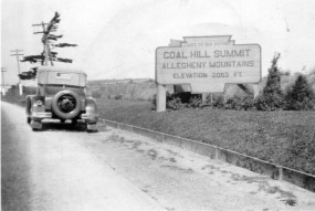
This photograph from the 1930s again demonstrates how familiar the keystone marker shape was in the Commonwealth from the 1910s until well after the Second World War. While this sign, announcing to motorists on the Lakes-to-Sea Highway that they had reached the Coal Hill Summit of the Allegheny Mountains, was much larger than the standard keystone marker, its shape was the same. Photo from the Fred Yenerall collection
Specific location unknown
