- COORDINATES: 41.679907, -79.411982 (approximate original location)
- COUNTY: Warren
- DISTANCE TO NEXT: Warren - 20
- EXPLANATION OF NAME: From the Indian "Far Outlook or View"
- FOUNDED: 1806
- MANUFACTURER: Undetermined
- SHAPE: Standard 1-sided
- STATUS: Photo is from the 1928 PA Dept of Highways report and is the earliest photo we have of any Keystone Marker. Courtesy of PA State Archives. Sadly the markers here no longer exist.
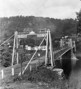
Courtesy of PA State Archives
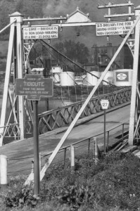
Detail.
PA Route 127 at west end of Allegheny River bridge

