- COORDINATES: 40.178843, -76.176932 are for approximate town center. Unknown exactly where this marker was located.
- COUNTY: Lancaster
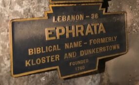
- DISTANCE TO NEXT: Lebanon - 36 This is an unusually large distance. There are likely other markers between these two towns.
- EXPLANATION OF NAME: Biblical Name Formerly "Kloster" and "Dunkerstown"
- FOUNDED: 1750
- MANUFACTURER: Undetermined
- STATUS: Was known only from Clair Clawser book, but presumed to be long gone. One turned up in 2023 at the Cocalico museum in Ephrata. Marker was restored and reinstalled Dec. 2023 by borough.
Feb. 2023 photo by JGL.
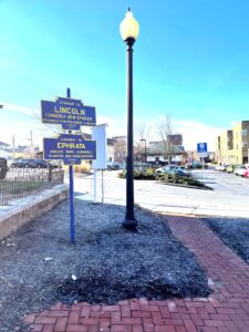
2025 photo
Marker was in collection of Cocalico Valley Historical Society..
Likely along U.S. Route 322Â Reinstalled Dec. 2023 on Ephrata town Rail Trail

